|
RAF WARTLING - RADAR STATION
|
|
||||||||||||||||||||||||||||||||||||||||||||||||||||||||||||||||||||||||||||||||||||||||||||||||||||||||||||||||||||||||||||||||||||||||||||||||||||||||||||||||||||||||||||||||||||||||||||||||||||||||||||||||||||||||||||||||||||||||||||||||||||||||||||||||||||||||||||||||||||||||||||||||||||||||||||||||||||||||||||||||
|
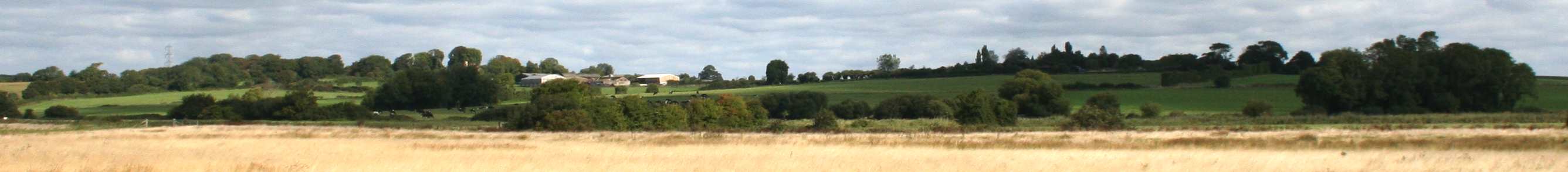
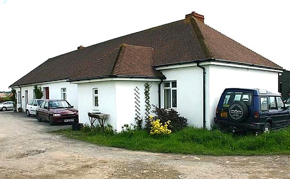
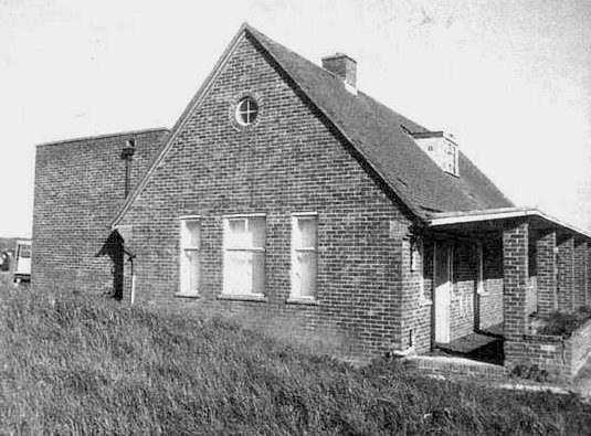
All is not what it seems from this picture. It looks for all the world like a series of gently rolling hills in the Sussex countryside, but actually, the hill on the right is Wartling Hill and on the left is RAF Wartling, or Bunker Hill. You can just make out the bungalow on the brow of the hill and another (modular) building, designed to look like a cow shed from the air, actually also a lift for taking supplies to the lower levels. In WW2 and through some of the Cold War period, Wartling was an important location in the defence of Great Britain - a fact seemingly overlooked by Wealden District Council and Natural England when it suits them.
1939 HISTORY
RAF Wartling was a Royal Air Force station located near the village of Wartling in East Sussex. It was a Second World War and later Cold War Ground Controlled Interception (GCI) station built to complement and supercede the nearby Chain Home station at RAF Pevensey that was technologically out of date.
PEVENSEY LEVELS = PYLON FARM
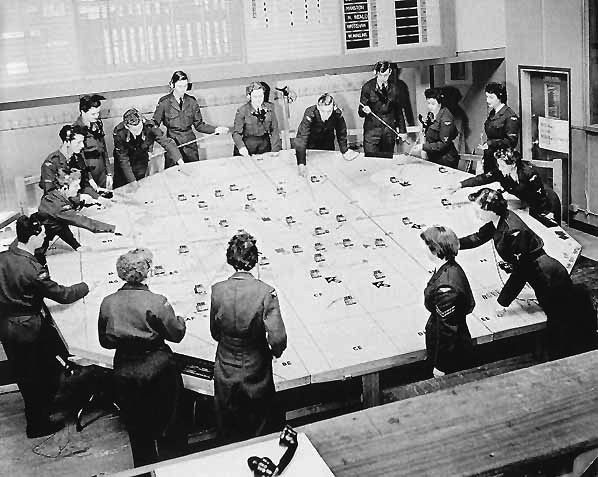
An East Coast Chain Home radar station was built on the Pevensey Levels in 1939; it was one of the original 20 Air Ministry Experimental Stations. Chain Home was at the forefront of a reporting network resulting in warning data being forwarded to the Fighter Command filter room at Bentley Priory where it was analyzed and displayed on the Fighter Command operations table. The information was then told to the Fighter Group HQ's from where the controller allocated the raids to be intercepted from sector airfields and controlled by the sector operations centre during the day and the fledgling GCI radar stations during darkness.
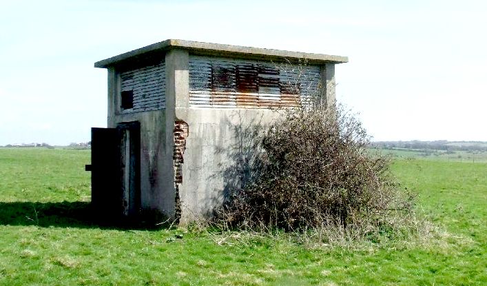
This innocuous rendered brick hut, is the entrance to the underground bunker at Wartling. One telltale sign of actual use is the louvers that suggest significant ventilation. The other sign is the concrete roof.
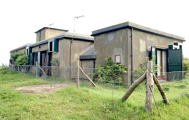
The modulator building at the top of Bunker Hill at Wartling, now a residential conversion, seen here in 2004. Gratefully, the works to change to a character cottage have managed to retain the original RAF look, no doubt with thanks from the archaeological community. Well done to the owners.
RAF
WARTLING
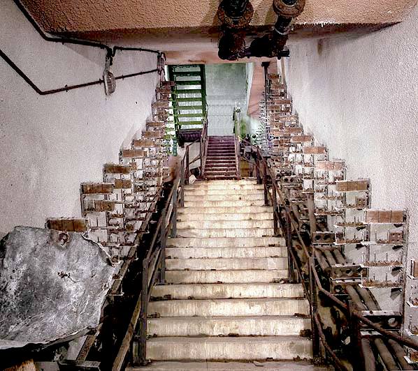
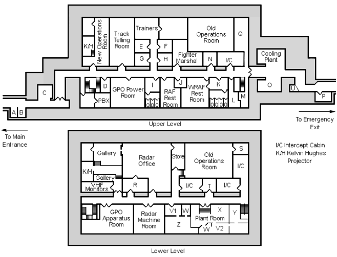
This is one of the entrances to the bunker - seen in the diagram below at the bottom left. There is a block built shed above ground leading to the steel staircase, then the concrete steps. Note the rows of empty cable support brackets, now stripped of electrical cables. Pity.
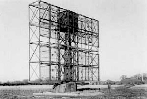
The GCI station was established in three stages: 'mobile', 'intermediate transportable' and 'final'. Early stations (from 1940) had equipment on wheeled caravans and temporary wooden hutting; these were replaced by intermediate stations which had the aerial arrays mounted above and below a
wooden gantry, with operations carried out from wooden huts.
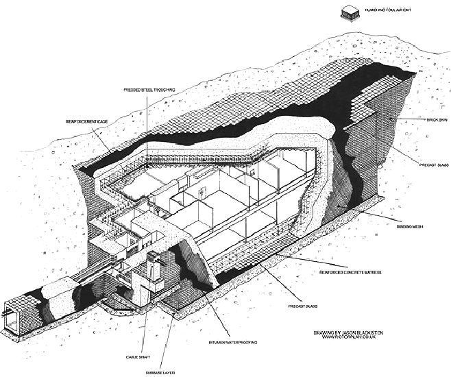
A nice drawing of the underground bunker at Wartling by Jason Blackstone. The author recalls entering the complex by a series of steel staircases shown at the bottom left, then going down concrete steps, turning left into the main corridor, via twin swing doors. It is a shame that this interesting industrial complex was not preserved intact for viewing by schools and colleges, etc.
1945 POST WWII CARETAKING
LEFT:
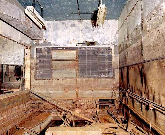
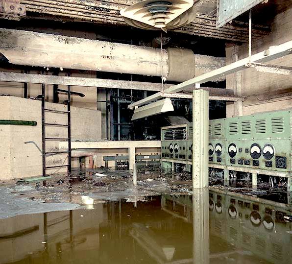
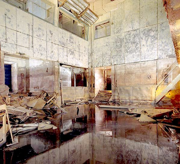
Intercept room after flooding in 2004.
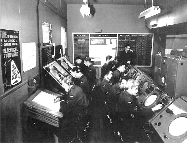
RIGHT: Intercept room during World War Two
1951 COLD WAR
With the threat of attack using nuclear weapons the station was used as part of the ROTOR air defence radar system and a protected underground operations rooms was built at Wartling. Construction started at the end of 1951 but was not completed until February 1955. In 1956 a new Decca Type 80 search radar was installed to replace the earlier equipment. With the increased range of the Type 80 radar other radar stations in the South East began to close and in April 1958 it became a Master Radar Station responsible for all British airspace South of the Thames. In 1959 it supplied the last known radar trace to accident investigators following the fatal crash of the prototype Handley Page Victor B.2 serial number XH668. When other Master Radar Stations were modernised in the 1960s Wartling went out of use and finally closed on 3 December 1964.
The R3 was never intended to survive a direct hit from a nuclear weapon but was designed to withstand a near miss from Russian pattern bombing with 2,200lb armour piercing high explosive bombs
(BRAB) dropped from 35,000 feet. It was decided to rebuild the GCI station at Wartling underground with a new two level R3 operations building alongside the old
Happidrome. Due to the location being barely above sea level, the trial test bores sunk to determine the site of the R3 indicated that the building would be liable to serious flooding if this location was chosen.
The transmitter block was converted to a residential cottage not long after 1989, in so doing losing all of its character and industrial interest. What a shame. This could have been a very interesting and unusual conversion.
It would have been too expensive to overcome this problem, so an alternative site was found on higher ground with the Type 7 radar scanner remaining at the old site as this was more suited for its performance. This radar was mounted above the underground operations room designated as an R7. During construction of the new station, the Happidrome remained fully operational and RAF Pevensey was reactivated as one of 15 stations promoted to a 'readiness chain home'. The station's radar was upgraded as part of the first phase of the Rotor 1 programme.
LEFT:
A
rotating T7 radar aerial on the Pevensey marshes, linked to the operations
rooms at Wartling. This was an important location in the defence of Great Britain. In WW2 the ground controller at Wartling had direct contact with the fighter aircraft they were controlling and in addition It is also recorded that a total of 380 German V1 'doodlebug' flying bombs were tracked and destroyed following interception by RAF Wartling personnel.
RIGHT: The guardhouse at Wartling. Note the similarity in design to the
building above the Beachy Head entrance, opposite the public house of the
same name.
1976 DISPOSAL OF WARTLING
When
sold by the MOD in 1976 the bunker was still in excellent internal condition. When inspected in 1970 the power was still connected; the lights worked and although stripped of most of its equipment all the teak flooring was still in place on both levels.
The unit was also watertight.
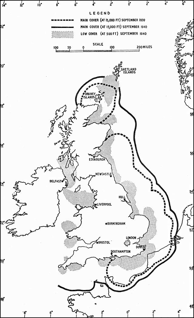
A map of the United Kingdom showing how the east coast was ring-fenced with GCI radar stations during World War Two. The only way for the German Luftwaffe to fly west past Southampton, in so doing reducing the range of their aircraft.
1996
SITE VISIT
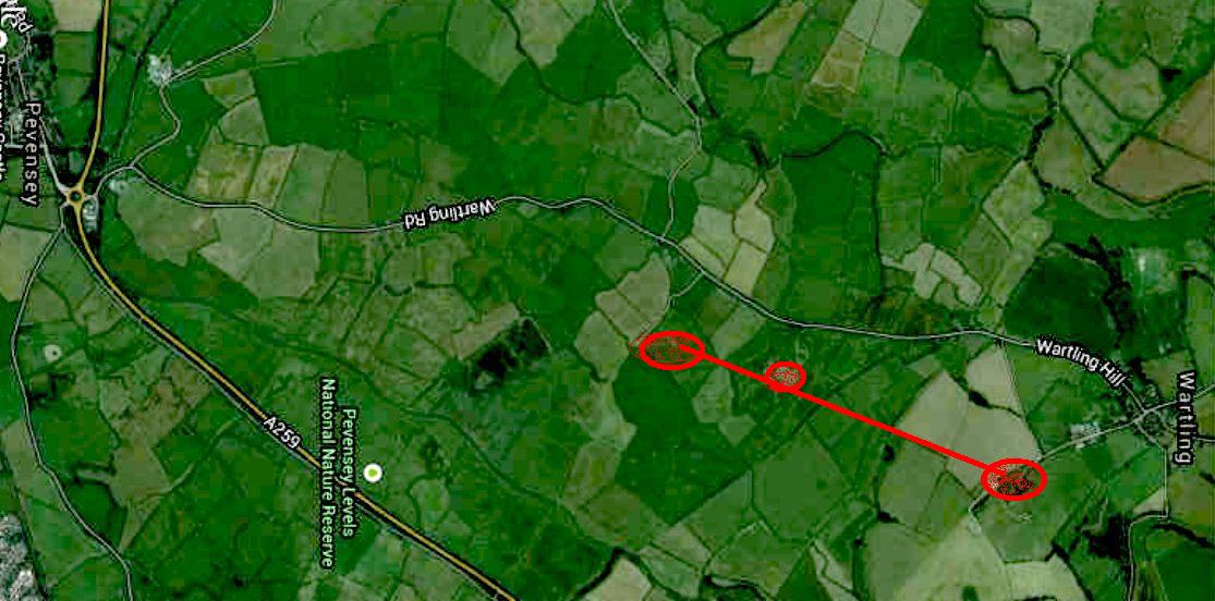
A Google map of the levels at Pevensey showing Radar Farm (A), Lion Farm (B) and the ex-MOD bunker on the hill in red (C). We have rotated the map clockwise by ninety degrees, so that south is east and north is west. Compare to the map below if you need to get your bearings. The point of this exercise is to show that the electrical conduits from Radar Farm (A) to the MOD bunker [Bunker Hill] (C) are more or less in straight line. It follows from this revelation that service roads, tracks and paths would have been along the line of excavations, with tracks at intervals running from Wartling road to the conduit line. RAF Pevensey is further south and west. On this map higher up and not visible.
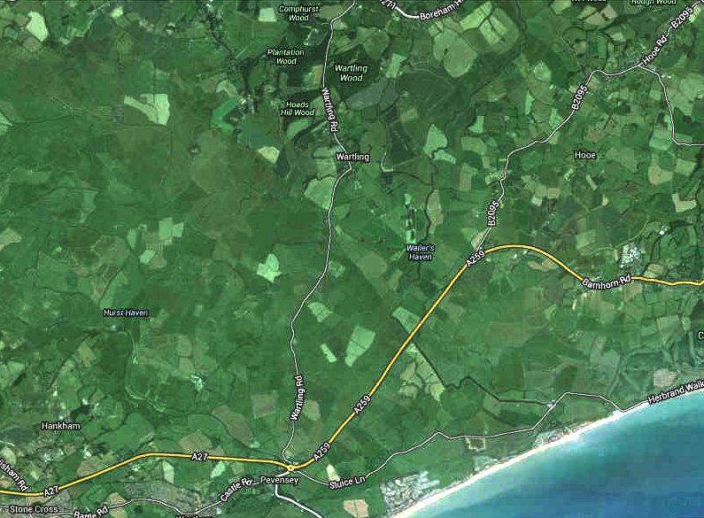
A Google map of the levels at Pevensey and the Wartling road, with correct north-south orientation.
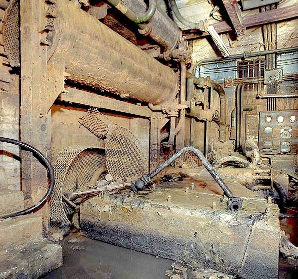
2004 SUBTERRANEA BRITANNICA
The above series of photographs taken by members of the Subterranae Britannica organization, have been slightly digitally enhanced to better show the utter devastation of what could have been a national scientific treasure. Full marks to the volunteers who gave their time to record as much as they could in a short timeframe. The author has visited similar installations at Beachy Head and Newhaven, not Newhaven Fort.
LEFT - Above is the RAF Memorial Plaque situated in Wartling Church. RAF Wartling opened on 30th October 1941 and closed on 30th April 1964. RIGHT - The Local History Group at Wartling hold regular events to celebrate and educate visiting members of the public.
GROUND CONTROLLED INTERCEPTION (GCI)
WORLD WAR TWO
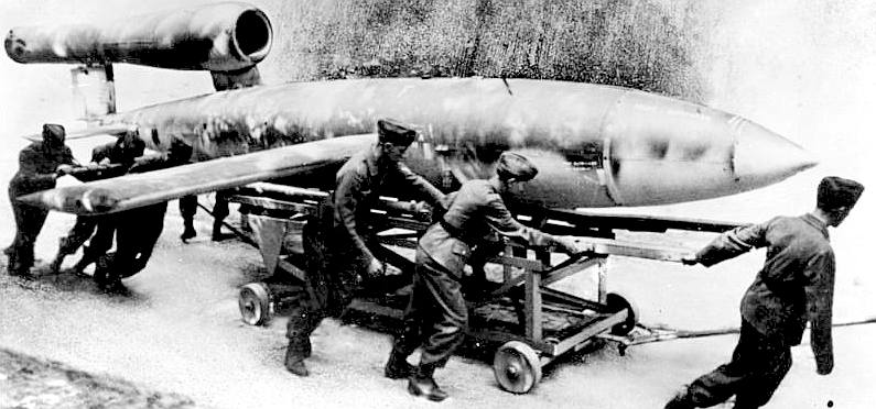
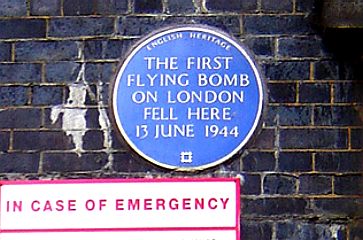
The first V-1 was launched at London on 13 June 1944), one week after (and prompted by) the successful Allied landing in Europe. At its peak, more than one hundred V-1s a day were fired at south-east England, 9,521 in total, decreasing in number as sites were overrun until October 1944, when the last V-1 site in range of Britain was overrun by Allied forces. After this, the V-1s were directed at the port of Antwerp and other targets in Belgium, with 2,448 V-1s being launched. The attacks stopped when the last launch site was overrun on 29 March 1945.
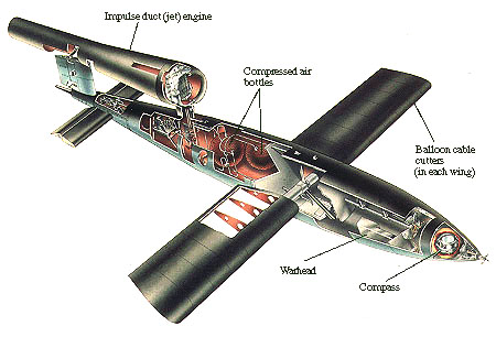
The ingenious V-1 flying bomb (German: Vergeltungswaffe 1)—also known to the Allies as the buzz bomb, or doodlebug, and in Germany as Kirschkern (cherrystone) or Maikäfer (maybug) — was an early pulse-jet-powered predecessor of the cruise missile. The V-1 was developed at Peenemünde Army Research Centre by the German Luftwaffe during the Second World War. During initial development it was known by the codename "Cherry Stone". The first of the so-called Vergeltungswaffen series designed for terror bombing of London, the V-1 was fired from launch sites along the French (Pas-de-Calais) and Dutch coasts.
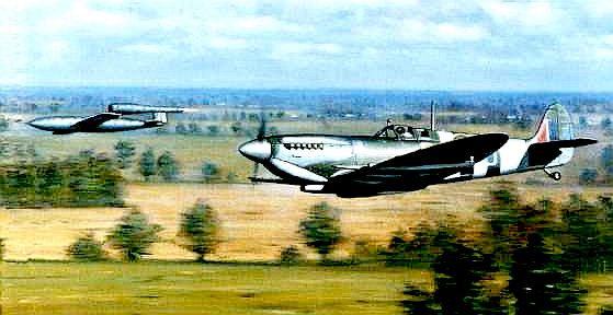
Equally adaptive, the British operated an arrangement of defences (including guns and fighter aircraft) to intercept the bombs before they reached their targets as part of Operation Crossbow, while the launch sites and underground V-1 storage depots were targets of strategic bombing. Spitfire pilots would tip the wings of the buzz bombs to make them crash on empty targets. During times of war, more radical ideas are employed than might be conceived in peacetime. In times of peace, the military simply make more of the same. Germany may have been led by a madman, but some of their scientists were geniuses.
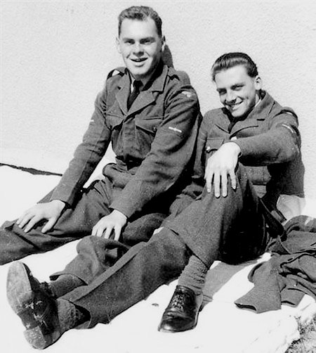
The photo above shows Michael Montegue (left) with friend Colin Warnett from Maidstone. "I played football for Little Common F.C. for the 1953 season, and was briefly associated with the Bexhill Swimming Club (Egerton Park) and Hastings and St Leonards Swimming Club. I would be particularly glad and grateful if anyone in Bexhill can help me with this request. I can be contacted by email at: emem@alphalink.com.au and/or my postal address: Villa 36 Burnside Village, Nicol Avenue, Burnside, Victoria, 3023, Australia. I also have a local (Eastbourne) contact: Mr Ron Ward on 769245 who will pass on any information."
LAND OWNERSHIP & WEALDEN DISTRICT COUNCIL
Wealden has an awful reputation when it comes to discrimination. The pattern emerging seems to be that they target foreigners who own land. The tactics involve using as many agencies (MAPPA) working together as they can muster, to apply pressure to the unlucky recipient. This is of course an abuse of authority, but routine malpractice in many regions, in denial of Article 14. In the words of Winston Churchill: "We will fight them on the beaches." This to eradicate discrimination. Why did we bother fighting two world wars and sign up to the European Convention of Human Rights and Fundamental Freedoms, and still allow one farmer more freedoms than another, simply because of nationality and status? MAPPA, operates a bit like the Nazi Gestapo and includes these and other agencies:
Local Council Inland Revenue Natural England Probation Service
The objective of these agencies, just like the Gestapo, is to use any pretext to incarcerate their victims, or otherwise cause financial or other harm. There is a list which, once a victim has been targeted, all of the agencies attack, one after another - save for those that might protect the interests of the target. A secondary aim is to weaken the resolve of the individual, especially if he or she is outspoken or dares to question the legality of local authority. This is ironic, given that RAF Wartling was a means to prevent a dictator taking over what should be a democratic UK, but that the dictators are now the civil service - enemy (of the public) within - suggestive that we might have been better off under Nazi rule.
Natural England's agenda is to ignore any archaeology that may be present on or under the land, in order to increase habitats for species, even where conservation of archaeology is a material consideration to protect irreplaceable remains. The local authority - in this case Wealden District Council, frequently neglect their duty to contact the County Archaeologist and/or English Heritage, when it is inconvenient to their agenda to harass targeted farmers. That particular duty just kind of slips their minds. It may also be that as officers of the court, that Natural England's solicitors and barrister also become absent minded when it comes to ensuring that proper procedure is followed by their client, in the rush to put in a massive bill, just in time for Christmas. Seen above are: Andy Hopkin (centre), Browne Jacobson LLP, solicitors Jonathan Mitchell (right), Ropewalk Chambers.
OUT OF DATE SSSIs = NEGLIGENCE
The Pevensey site has not been surveyed for historic remains, nor updated as to SSSI validity since about 2011. It is unclear if the 1977 notification was reassessed in 1990 - with the benefit of proper collated figures as to actual levels of populations, or, whether the notification was simply rubber stamped for convenience. It appears to us that they were simply rubber stamped unchecked as to accuracy, hence, any litigation, etc, might be described as a fraud upon a power.
Either way, where prosecutions are being based on out of date statistics and use, those prosecutions are poorly founded and may well be an abuse of process.
Pevensey Levels - Should this be an area of special scientific interest, or should archaeology be given more importance? For sure some parts of the land are special for their World War II archaeology. Much of the land in this region has been artificially manipulated as a result of emplacements and radar, early warning stations. How then can the whole site be classed as natural - rather it is man-made - so not natural - indeed unnatural. Why then is Natural England involved? Natural England of course refuse to seek advice from the experts such as English Heritage, even though there is a duty to protect industrial archaeology. The officers dealing with this case are Sue Beale and Cath Jackson. James Cross in the new chief executive and Allan Drewitt is the in-house ornithologist.
INDUSTRIAL ARCHAEOLOGY
Industrial archaeology (IA) is the systematic study of material evidence associated with the
industrial past. This evidence, collectively referred to as industrial heritage, includes buildings, machinery, artifacts, sites, infrastructure, documents and other items associated with the production, manufacture, extraction, transport or construction of a product or range of products. The field of industrial archaeology incorporates a range of disciplines including archaeology, architecture, construction, engineering, historic preservation, museology, technology, urban planning and other specialties, in order to piece together the history of past industrial activities. The scientific interpretation of material evidence is often necessary, as the written record of many industrial techniques is often incomplete or nonexistent. Industrial archaeology includes both the examination of standing structures and sites that must be studied by an excavation.
A commemorative plaque installed by English Heritage at the Mile End Road, London, which was the site of the first V1 bombing.
GCI RADAR STATION SITES IN THE UK - A to Z
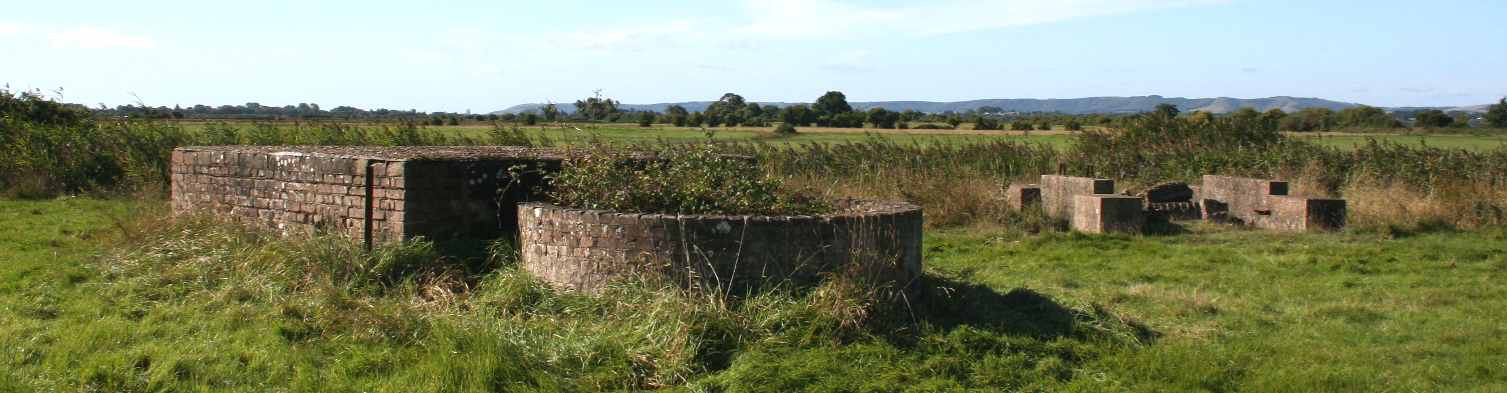
Radar Farm is screened by fencing and trees, but the archaeology is for the most part well preserved, thanks to the company operating it being in tune with conservation ideals.
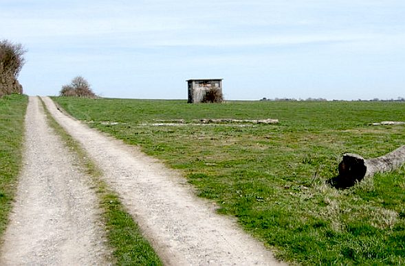
Typical of the tracks on the marshes that were made to be able to build the structures and also to be able to service the installations.
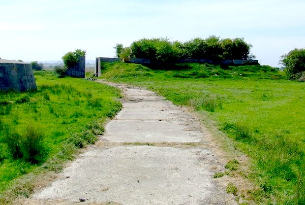
This is the track leading up to the GCI entrance on Bunker Hill. Once again demonstrating that this area was criss-crossed with access paths and the like - many of which have become overgrown and forgotten.
YOUTUBE
LINKS & REFERENCE
Subterranea Brittanica Wartling RAF GCI radar_station Wikipedia ground-controlled_interception http://en.wikipedia.org/wiki/ROTOR http://www.pamdoodes.com/wartling-news-and-views.php https://www.google.co.uk/maps http://en.wikipedia.org/wiki/V-1_flying_bomb http://en.wikipedia.org/wiki/Industrial_archaeology http://industrial-archaeology.org/ http://www.rafmuseum.org.uk/ http://www.rafmuseum.org.uk/about-us/partners/raf-historical-society.aspx http://www.english-heritage.org.uk/ https://www.gov.uk/government/organisations/natural-england http://www.newhavenfort.org.uk/ http://en.wikipedia.org/wiki/Luftwaffe http://en.wikipedia.org/wiki/Multi-Agency_Public_Protection_Arrangements http://www.eastsussex.gov.uk/ http://www.pamdoodes.com/wartling-news-and-views.php http://en.wikipedia.org/wiki/Wartling http://en.wikipedia.org/wiki/Ground-controlled_interception http://www.subbrit.org.uk/rsg/sites/w/wartling/ http://en.wikipedia.org/wiki/ROTOR http://en.wikipedia.org/wiki/RAF_Wartling http://www.naturalengland.org.uk/ Spitfire Site Sgt Jean (Sally) Semple early-radar-memories http://spitfiresite.com/2010/04/early-radar-memories.html/2 Subbrit wartling_gci_radar_station http://www.subbrit.org.uk/sb-sites/sites/w/wartling%28raf%29_gci_radar_station/index.shtml
|
|||||||||||||||||||||||||||||||||||||||||||||||||||||||||||||||||||||||||||||||||||||||||||||||||||||||||||||||||||||||||||||||||||||||||||||||||||||||||||||||||||||||||||||||||||||||||||||||||||||||||||||||||||||||||||||||||||||||||||||||||||||||||||||||||||||||||||||||||||||||||||||||||||||||||||||||||||||||||||||||||
FAIR USE NOTICE
This site contains copyrighted material the use of which has not always been specifically authorized by the copyright owner. We are making such material available in our efforts to advance understanding of environmental, political, human rights, economic, scientific, and social justice issues, etc. We believe this constitutes a 'fair use' of any such copyrighted material as provided for in section 107 of the US Copyright Law. In accordance with Title 17 U.S.C. Section 107, the material on this site is distributed without profit to those who have expressed a prior interest in receiving the included information for research and educational purposes. |
|||||||||||||||||||||||||||||||||||||||||||||||||||||||||||||||||||||||||||||||||||||||||||||||||||||||||||||||||||||||||||||||||||||||||||||||||||||||||||||||||||||||||||||||||||||||||||||||||||||||||||||||||||||||||||||||||||||||||||||||||||||||||||||||||||||||||||||||||||||||||||||||||||||||||||||||||||||||||||||||||
|
This site is protected under Article10 of the European Convention on Human Rights and Fundamental Freedoms. |
|||||||||||||||||||||||||||||||||||||||||||||||||||||||||||||||||||||||||||||||||||||||||||||||||||||||||||||||||||||||||||||||||||||||||||||||||||||||||||||||||||||||||||||||||||||||||||||||||||||||||||||||||||||||||||||||||||||||||||||||||||||||||||||||||||||||||||||||||||||||||||||||||||||||||||||||||||||||||||||||||